


Do you happen to know what Peter Warren Dease, Edward Smith, Robert McVicar, John George McTavish, and George Keith all have in common?
To begin with, they were all Chief Factors with the Hudson’s Bay Company during the 1800’s, and a couple of them even worked for the HBC’s hated rival, the Northwest Company, before it was forced to merge with the HBC in 1821.
In addition, they all assisted Sir John Franklin in one way or another during one, and in some cases, both of his overland expeditions.
Is there anything else that comes to mind?
Let me give you a hint – focus on their last names only:
• Dease
• Smith
• Keith
• McVicar
• McTavish
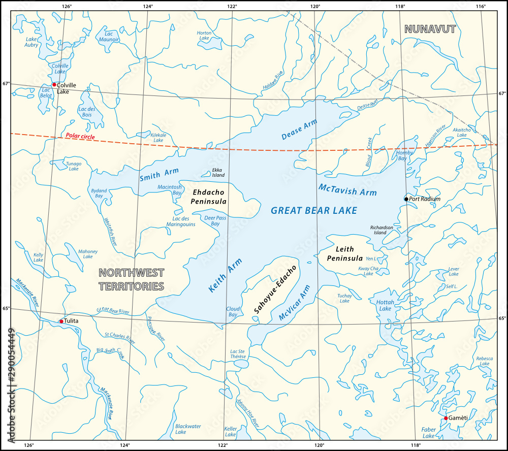
Well, if it hasn’t rung a bell as yet, have a closer look at the map at the top of the page, and hopefully it has now dawned on you that these are the gentlemen whose names grace the five distinct arms of Great Bear Lake.
While Sir John Franklin, and John Richardson conferred the names in the early to mid 1800’s, they did not start to appear on the official topographical maps of Canada until they were officially approved, beginning in 1910.
So without further adieu, let me introduce you to these brothers in “arms.”
Keith Arm
Named after Chief Factor, George Keith. He was in charge of Fort Chipewyan during Sir John Franklin’s first expedition, 1819-1822. Franklin named the arm after Keith on his Second Overland Expedition, 1825-1827.
For an excellent biographical sketch of George, and his many accomplishments, go to:
Dease Arm
Named by Sir John, after Chief Factor, Peter Warren Dease, who accompanied him on his second overland expedition, from 1825 to 1827. Dease was also the senior officer on the Dease/Simpson expedition, 1837-1839.
A biographical sketch of Peter can be found at:
McTavish Arm
Named after John George McTavish, by John Richardson, who surveyed Great Bear Lake in 1826, in conjunction with Franklin’s second overland expedition. Both McTavish and Richardson were Chief Factors who assisted Franklin during both of his overland expeditions.
A comprehensive account of John Georges’ many contributions to the fur trade in Canada, is available at:
McVicar Arm
John Richardson named this arm after Chief Factor, Robert McVicar. Like George McTavish, he assisted Franklin during both of his overland expeditions. Unlike the others, this arm has a traditional Dene name – Turíli.
John’s biography can be found at:
Smith Arm
Named after Chief Factor, Edward Smith, by Franklin during his second overland expedition. In 1924, Dominion Land Surveyor, H.E. Pearson proposed that the arm be renamed, “Good Hope Arm,” but his proposal was not accepted.
Unfortunately, I have been unable to find much in the way of biographical information about Edward, but it’s clear from what little is available, he was well thought of by his employer, and was a major player in the fur trade within the Mackenzie District.
That said, I did come across a brief biographical sheet produced by the HBC, that can be found at:
https://www.gov.mb.ca/chc/archives/_assets/docs/hbca/biographical/s/smith_edward.pdf
And finally, special thanks to Alison Galloway Technologist, Geospatial/Data Services Natural Resources Canada, Geographical Names Board of Canada, for providing the following technical and historical background information for this article.
The following is origin information that the Geographical Names Board has for each of the 5 arms of Great Bear Lake.
There are several approval dates for the same feature due to the fact that each arm is located on more than one topographical map sheet and therefore was approved on different dates on some of these maps.
Presumably the name, once it had been officially approved, would have then appeared on any of the topographical maps on which the feature is located.
Smith Arm
Approved 1945-01-15 .Named by Franklin (see 0863 1 April/24). In 1924 H.E. Pearson, D.L.S. proposed Good Hope Arm as local usage but the e Board retained South Arm. Named by Franklin 1826 after Edward Smith, Chief Factor, H.B. Co.
Dease Arm
Approved 1910-12-31. 9th Report: Dease, bay, Great Bear Lake, named by Franklin after Peter Warren Dease, Chief Factor, H.B. Co., accompanied Franklin’s exped. 1825-27, senior officer of the Dease and Simpson exped., 1837-39. G.B. of C in June 1924 favoured changing generic to “arm”.
McTavish Arm
Approved 1949-02-04 .Also approved 12-12-39 (86 E) at 65 52 – 118 47 amended to 66 0 0 – 118 47. Carded for 86NW and 86 NE at 66 24 – 118 03. Submitted 29 Dec/38 by W.H. Boyd. Submitted 22 Nov/48 by M.G. Cameron, Chief Cartographer (86 ‘K/5). Used on maps since 1932. After John George McTavish, Chief Factor of t he H.B. Co. (Franklin, 1827) 9th Report.
McVicar Arm
Approved 1944-11-06 .McVicar Arm approved on 96 SW and 96 SE at 65 05 – 120 40 amended to 65 20 – 120 10. Also approved 6 May/24 (file 0863) and approved 12-12 -39 (86E).
Keith Arm
First approved 1944-12-12. Carded for 96H at 65 15′-121 57′. Approved 3 April 1959 (96G) at 65 15′-122 30′. 9th Report: Keith Bay after George Keith chief factor of H.B.Co. and who was in charge of Fort Chipewyan during Franklin’s expedition 1819-1822. Locally used name confirmed December 17, 1958, by O.F. Elisson, Game Officer.


