Mare incognitum - The Unknown Sea
 Written by
Harold
Written by
Harold
- Published in Stories and Articles
- Read 6240 times
- font size decrease font size increase font size
You would think it would be rather hard to miss.
The fact is, it wasn’t all that many years ago that Great Bear Lake, and much of the surrounding area, remained virtually “unexplored” in a contemporary sense. While the Sahtu Dene have been intimately familiar with the area for hundreds of years, it was not until the 1800’s that Great Bear began to generate some interest in the “outside” world.
Those seeking a Northwest Passage mapped much of Canada’s Arctic coastline throughout the late 1700 and early 1800’s, but the interior of the continent, and in particular what we now refer to as the Northwest Territories and Nunavut, remained largely “unexplored.”
Peter Pond, the noted fur trader and explorer had apparently heard about Great Bear in the late 1700’s, but other than similar bits of random, anecdotal information, very little was known about the giant, mysterious freshwater sea that dominates the northwestern arctic and sub-arctic regions of Canada.
Until the mid 1800’s Great Bear rarely appeared on maps, and in those rare cases where it did, there was little or no resemblance to the lake, as we know it today.
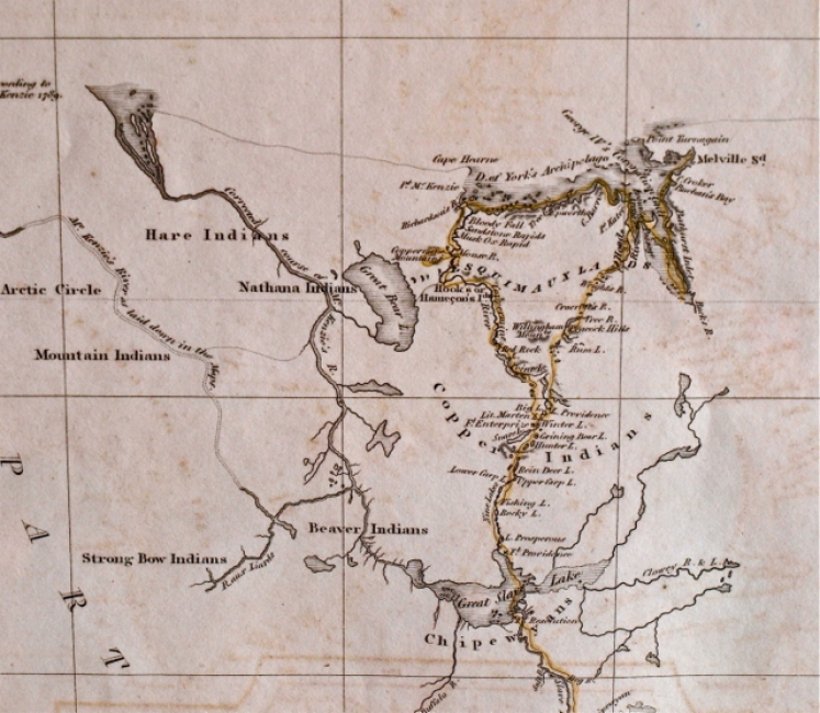
The above excerpt from a map published in 1827, is described as: “A Chart of the Discoveries of Captains Ross, Parry and Franklin in the Arctic Regions – In the years 1818-1819-1820-1821&1822,” and shows what was generally known about the size, and shape of Great Bear Lake during that time period.
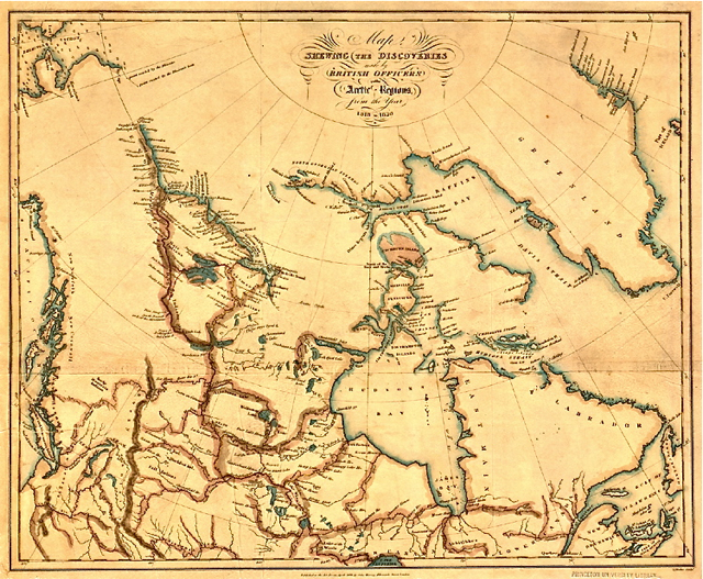
In 1825, Sir John Franklin, while on his second overland expedition, dispatched John Richardson to map the east end of Great Bear Lake, and once he had completed this rather arduous task, maps began to appear outlining the big lake in a more recognizable way.
You can see the results of his efforts below, on the map that was included in Sir John’s, “Narrative of Second Expedition to the Shores of the Polar Sea,” published in 1828.
Having said that, while some detailed mapping obviously did take place throughout the 1800’s, to further demonstrate how isolated Great Bear Lake was, it’s largest inflowing river, the Camsell, was not named until 1900.
When travelling to Great Bear by air in the late 1920’s and 1930’s, large tracts of land remained unmapped for flying purposes. There were no weather reports, and if you wanted to find it, you flew by sight, usually following a series of rivers.
Fredrick B Watt, in his book “Great Bear – A Journey Remembered,” which chronicles his experiences on the lake as a prospector’s assistant in the early 1930’s, said this about it:
“It is giant among the world’s freshwater seas. Astride the Arctic Circle, it is instantly identifiable on the smallest-scale map of Canada.
This is Great Bear Lake, long shrouded in mystery and superstition.”
Perhaps he should have said, “…still shrouded in mystery and superstition,” because now, as it was over 200 years ago, only a handful of people visit each year, and while our overall knowledge has certainly increased, that knowledge resides in relatively few hands, and to this day, little has been published that is available for public consumption.
Cartographers once labeled unknown regions on their maps with phrases such as “Here be Dragons,” and included pictures of fantastic beasts and large serpents, claiming they were lying in wait for unsuspecting travellers, who dared to probe these unknown places in the remote corners of the world.
I don’t know about you, but on my next visit to Great Bear Lake, I plan on keeping a sharp lookout - just in case they were right.